Friday, May 6, 2011

Chapter 18:Hawaii

Beautiful Hawaii... I haven't been lucky enough to go there yet but I have heard great things. Hawaii is near the middle of the Pacific Ocean.Until the last two centuries, Hawaii has been able to keep isolated. However now, these islands have become an important focus of shipping, whaling, and political maneuvering.

 Hawaii's oceanic location greatly affects the climate.  It surprised me to hear that Honolulu's record high was 88*F. I'm used to Arizona heat at 120*, 88* is nothing. Their high temperatures occur in September and October. There is little seasonal change in temperature because it has a tropical location. The islands' topography creates an extreme variations in precipitation from one location to another.


Sugar and pineapple fueled the Hawaii's economy for decades after the 1860s. The relative importance of agriculture has declined greatly. Even though they provide a substantial share of the world's sugar harvest.

Today, over 7.4 million people visit Hawaii each year. Tourism produces over $1 billion per year for the Hawaiian economy and employs more than 171,000 people. It also brings upon a negative aspect of it. The more tourists you have the more hotels being built along the beautiful island.


Wednesday, May 4, 2011

Chapter 16:The North Pacific Coast

Much of the North Pacific Coast's regional character is tied up in beauty and bounty of its landscapes. Another key component is the relative location. Precipitation is high here because of its maritime influences. The greatest average annual precipitation on the continent is found there; averages above 190 centimeters are common. However, not all of the Northern Pacific Coast has high precipitation. Mountains are the main reason for the high precipitation and the substantial climatic variations that exist inland.


Not surprisingly, the North Pacific Coast is a land of mountains. Except for the tundra above the treeline and the drier lowlands, all of the North Pacific Coast is, or was, covered by forest. Tree growth is encouraged by the region's plentiful moisture and moderate winter temperatures. No other part of Canada or the United States provide as much lumber as the North Pacific Coast.


More than 10 million people live in the North Pacific Coast.Most live in a long cluster of cities and towns along the lowland. Seattle has been the largest city along the North Pacific Coast since its boom era of the late nineteenth century.


Tuesday, May 3, 2011

Chapter 15: California

Good old California. Home of some of the greatest legends. And a place I like to call home as well. Many people have skewed vision of California. Whether they believe a lot of dumb people live here or if they believe it's the best place to be, all the rumors are probably true. California is home to 12 percent of Americans. With that many people you are bound to have a melting pot of people, which is just what California is. There are many contrasts in California, from the Northern parts to the Southern parts, or even the varied topography. California has the lowest and highest elevations in the coterminous United States; Death Valley and Mount Whitney. Even the weather is dramatic, 90 degrees one day and the next day could be rainy and 60 degrees. People either love California or hate it.


Luckily we don't have to worry about hurricanes or tornadoes. However, earthquakes are definitely our enemy. Small earthquakes are very common across California and the large ones come occasionally. Wildfires are also something we have to be cautious of. In the hot and dry months in the fall, wildfires always seem to kick our butts.

The climate in California is called Mediterranean climate. It is climate with moderate precipitation concentrated almost always in the winter months, and one that has mild winters and hot summers.


The variety of climatic regions and the market demand of California's own bulging population are the principle contributors to the state's crop diversity. Many cities are located in the midst of good farmland, and urban land users prefer the same flat land that is most valuable to farmers. One problem is that urban expansion, may become even more so as some farmers choose not to sell their land until surrounding land is urbanized.

Overall, I think most people would agree California isn't such a bad place to live after all.


Monday, May 2, 2011

Chapter 14: The Southwest Border Area

Today, the Southwest Border Area's tricultural complexity lends it its special character. Acculturation (cultural borrowing and sharing among groups) in the Southwest Border Area became more complex when Anglos arrived. The cultural impact of Indian and Spanish groups on the regional landscapes is obvious. Spaniards expanded into the Southwest from their colonial core in Mexico. When they encountered a difficult or different environment, the expansion halted. The aridity of Arizona, New Mexico, and bordering areas in Utah and Colorado discouraged large scale Anglo agricultural settlement in the nineteenth century.

Nowhere else in the world do high-income and low-income societies meet in such close geographic proximity as along the U.S -Mexico border. In 1965 Mexico started the Border Industrialization Program to attract U.S. labor-intensive manufacturing industries to border communities in northern Mexico. For Mexico, this program offered the possibility of jobs for its people.


Like I stated in an earlier bog, the book states that large retirement communities have sprouted in the desert.  One main attraction in Lake Havasu City, Arizona is the London Bridge, where it arches over a newly created and artificially maintained waterway. This is one landmark people remember from Lake Havasu.

In 1967, the Common Council of the City of London placed the bridge on the market and began to look for potential buyers. On 18 April 1968, Rennie's bridge was sold to the American entrepreneur Robert P. McCulloch of McCulloch Oil for $2,460,000. When casting his bid for the bridge, McCulloch doubled the estimated cost of dismantling the structure, which was $1.2 million, bringing the price to $2.4 million. He then added on $60,000, a thousand dollars for each year of his age at the time he estimated the bridge would be raised in Arizona. His gesture earned him the winning bid.


http://www.golakehavasu.com/history-of-london-bridge.html

Sunday, May 1, 2011

Chapter 13: The Empty Interior

This large area of sparse population stretches from the Rocky Mountains' eastern slopes west to the Sierra Nevada of California, the Cascade Range of the Pacific Northwest, and the coast of British Columbia. . The population density is so low across this space; hence the name "The Empty Interior".  Most of the region is filled with plateaus rather than mountains. The Colorado Plateau is a beautiful example. Lake Havasu City, AZ definitely doesn't have anything this amazing.However, this plateau does run along the middle Colorado River in Utah and Arizona. I have been on the Colorado river and the only thing I remember about it is it was freezing, narrow, and choppy water! This plateau isn't event the biggest in the Empty Interior.


Nearly all of the area in the United States that can be classified as desert is found in the Empty Interior or in the Southwest borderlands.

Irrigated crops dominate agricultural production in the Empty Interior. Without irrigation, a stable agricultural economy would be impossible in this dry region. Today, Arizona depends on subsurface waters to supply several times as much water as the Gila-Salt River system. The pressures on a deficient water supply are growing more acute throughout the drier southern half of the Empty Interior.

Friday, April 29, 2011

Chapter 12: The Great Plains and Prairies

The European settlers had encountered several environmental surprises on the Great Plains. One negative thing about the Great Plains is that they have the coldest winters and hottest summers. The weather is very extreme.

Contrary to many peoples' belief of the land being flat, the Great Plains has a varied landscape.  Another misconception about the Great Plains is that the people all share the same ethnic background. However, the Great Plains actually has many different cultures which make is so diverse.

The strongest images of a place are portrayed in the songs, folktales, and literature. I did not realized that the land influences the work of authors so much as it does.

 The agriculture in the Great Plains is large scale. Instead of having man labor work the fields they have intensive machinery use. The most important crop grown in the region by far is wheat.

Tuesday, April 19, 2011

Chapter 11: The Agricultural Core

 The agricultural core is defined by its aura of small-town, rural America. The cultural tones underlying it are strong and indisputably agrarian. The people are politically and socially conservative, independent and often friendly to strangers. Unlike Arizona, most of the agricultural core's residents are white descendants of waves of foreign-born migrants. Most people in Arizona are of white descendants but just not foreign. In Lake Havasu City specifically, there are mainly elder Caucasians. There is not as many people with diverse backgrounds in Arizona as there is in California.

Just like the people in the agricultural core, the people in Arizona are also politically and socially conservative, independent and often friendly to strangers. This is one of the main things that attract my fiance and I to Arizona.  California can be filled with stuck up people at times. It is nice to be around genuinely nice people who are laid bacck.

The agricultural core's landscape rolls gently with a few areas of flat or hilly terrain. The persistently rolling landscape permits good soil drainage and restricts swamps to small areas. Their soil falls into two basic groups- alfisols and mollisol. Alfisols form under conditions of moderate moisture and usually associated with coniferous or mixed forests. Mollisols are suited for grain production and are most fertile soil group in the agricultural core.

Sunday, April 17, 2011

Chapter 10: The Southern Coastlands- On the Subtropical Margin

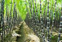
    Unlike the Southern Coastlands, Arizona is a desert with dry, hot weather. The Southern Coastlands are a subtropical place that is very humid. One of the main things I love about Arizona is that it is a dry heat (being a girl and all I like that I can go outside and my hair won't get frizzy from the humidity). However, because of their humid weather, they are able to grow crops that most other places cannot. The region's most important specialty crops are citrus fruits, rice, and sugarcane. Only few places can successfully grow sugarcane, it's growing conditions are very specific. The leading cash crop in Arizona isn't even a food it is cotton. Due to their hot weather, they are limited to what they can farm. Cotton seems to be the most successful, which makes sense.
      Quite similar to Lake Havasu City, Florida is a tourist attraction, and a prime place for people to retire. The one bad thing about the Southern Coastlands' subtropical weather is the inevitable mid-winter frost reaches southern Florida. They also have more sporadic, dramatic, and destructive hurricanes than in North America. Hurricanes are created by intense solar heating over large bodies of warm water . Then a massive low-pressure atmospheric pocket forms, drawing in warm, moist air. The deeper the pocket, the faster the wind flows and the more destructive the storm's potential.

The ability to reach inland sources of exchange is more important in creating trade than physical facilities. Rail connections strengthened each harbor's access to North America's major inland markets. However, the city was well established before highway connections reinforced its growth.

The two of the three leading petroleum-producing states are Texas and Louisiana (Alaska being the third). Arizona currently has no oil refineries and only two pipelines which transport almost all of Arizona’s gasoline from Texas, New Mexico and California. It takes a gallon of gasoline approximately 7 days to travel through the West Line from California to Phoenix and approximately 6 days to travel on the East Line from El Paso, Texas to Phoenix. A small percentage of the state’s gasoline is trucked in from neighboring states. Arizona’s state and federal gasoline taxes are 37.4 cents per gallon. Comparatively, California’s state and federal taxes are 60 cents per gallon (another reason why moving to Arizona doesn't sound half bad), while Nevada consumers pay 51.9 cents per gallon. (Source: American Petroleum Institute)


http://www.azag.gov/consumer/gasoline/gas.htmlhttp://www.city-data.com/states/Arizona-Agriculture.html

Tuesday, March 15, 2011

Chapter 9:The Changing South

As stated in this chapter, Southerners are truly proud to call themselves southerners. They passionately believe in their freedoms and traditions. Their culture is so rich with their country music, delicious food and just their laid back mentality. The slaves' presence in the south meant that their influence on their culture was heavy. For example, their speech patterns, diet, and music was highly influenced by the African slaves.


The religion data for the Maricopa County in Arizona shows that 43% of people are Catholic. This seems to be normal in most U.S. States this is the case. However, in the South, they are adherent to the evangelical Protestant religions. The Baptists are dominating in the South. 


More than one-fifth of Arizonans live in poverty, a figure higher than anywhere else in the nation except Mississippi. Figures from the U.S. Census Bureau show nearly 1.4 million Arizonans in households earning less than the federal poverty level - about 21.2 percent. This is definitely shocking news to me. Coming from a small middle class town, I did not know that Arizona is the number 2 state in poverty.

Racial segregation, unfortunately, seems to live on. Recently in Tempe, Arizona at Arizona State University, they had English 101 and 102 classes opened to "Native Americans only".This is not the kind of racial segregation people are used to seeing, however, it is the kind of segregation happening in this modern day world.

                                          
Unlike the South, Arizona does not want more government involvement in their daily lives. It did help the South in economic and social matters.


http://azstarnet.com/news/local/article_551a7372-415a-5dc5-a27d-ab19a1171e81.html

Chapter 8: Appalachia and The Ozarks

The Appalachian Mountain's rugged landscape played a major role in the settlement history of the United States. Without the mountains acting as a barrier, the European settlement may have spread inland more thinly and more quickly. The Appalachians definitely define the North America's resource geography and chart on economic history and population distribution. 


The Appalachia and the Ozark are found in the following states: Missouri, Oklahoma, Arkansas, Pennsylvania, West Virginia, Tennessee, Kentucky, and it touches neighboring states as well. 
Although the Appalachia and Ozark's don't reach to Arizona, I can use this topic to talk a little about the Grand Canyon.


The Grand Canyon can be found in Arizona. This phenomenal 277 mile long and 18 mile wide chasm was formed by the Colorado River.  This beauty took 3 to 6 million years to form,and erosion continues to change its contour. Although I have been to Arizona hundreds of times,sadly, I still have not made it to visit the Grand Canyon!


http://www.explorethecanyon.com/explore-learn/grand-canyon-facts.cfm

Chapter 7: The Bypassed East

The area that compromises the Atlantic Providences of Canada as well as northern New England and the Adirondacks of New York is called the Bypassed East. It lies in a transportation shadow thrown by nearby regions. Most of the Bypassed East is part of the Appalachian Highlands' northeastern extension.The climate in the Bypassed East is where polar, continental and maritime weather systems mix. It is sometimes hot, sometimes cold, and normally humid.It differs from the climate of Arizona where it us usually hot and dry. Higher inland elevations further increase the substantial climactic difference between the region's coastal and interior lands.

The agriculture's regional importance has continued to decline across most of the Bypassed East. Arizona's agricultural output is evenly distributed between crops and livestock. About 47% of Arizona's agricultural production is in livestock. The other 53% is in crops. Arizona's top five agricultural products are cattle and calves, lettuce, dairy products, cotton, and hay. Its biggest crop is lettuce, comprising about 20% of the state's total crop production.


They also are a leading cotton-producing state ranking 10th in the nation. Hay and greenhouse and nursery production each generate about 1/2 of the revenues provided by cotton. Beef cattle, including calves are the leading source of Arizona farm income, followed by dairy products. Some hogs and sheep and lambs are also produced in the state.
As far as mining goes Copper is the most important mined product of Arizona.


http://www.netstate.com/economy/az_economy.htm

Thursday, March 3, 2011

Chapter 5: The North American Manufacturing Core

Most everything we come in contact with in this world is manufactured. Although many items are manufactured out of the United States, industry located in the U.S. and Canada still produce most of what people in both countries consume. Manufacturing's role in defining a continental core suggests how important this form of economic activity is in defining the character of the United States and Canada. The manufacturing core is very close to the important ports, main communication centers, and the financial centers in both countries.


The United States has become a service economy and many states, Arizona included, generate most of their revenue through service industries.The spending of tourists and retired people contribute a lot to the revenue.
Arizona's manufacturing revenues are generated from high tech products like computers, electronic equipment, and aerospace vehicles.
Manufacturers add value to raw products by creating manufactured items. For example, cotton cloth becomes more valuable than a boll of cotton through manufacturing. In terms of value added, Computer and electronic equipment (computer microchips) and electronic components, including communication systems, are Arizona's most important manufactured goods. Arizona’s manufacturing exports fell 16 percent during this time while overall U.S. manufacturing exports rose 70 percent. Manufactured exports support 23 percent of Arizona's manufacturing jobs.


http://www.netstate.com/economy/az_economy.htm
http://www.nam.org/~/media/F8DA7ACD941C46BDAA9D2B430D7102EF.ashx

Thursday, February 24, 2011

Chapter 4: Megalopolis

Although Arizona is not included in the Megalopolis, it still manages to hold it's own to other states. The Megalopolis can be found along the northeastern coast of the United States by large, independent metropolitan areas such as Boston, New York, Philadelphia, Baltimore, and Washington, D.C. The main theme of Megalopolis is it's urbanness.


 Besides its large buildings, apartments on every corner, small shops, huge shopping centers, factories etc.,  Megalopolis also contains parks and other land available for recreational and agricultural use.

Saturday, February 12, 2011

Chapter 3: Foundations of Human Activity

Arizona was the 48th state in the United States. It became a state in February 14, 1912. According to the website below, The word Arizona comes from one of the following: the Aztec Indian word "arizuma," that means "silver-bearing". 

According to Wikipedia, The first Native Americans arrived in Arizona between 16,000 BC and 10,000 BC, while the history of Arizona as recorded by Europeans began when Marcos de Niza, a Franciscan, explored the area in 1539. Coronado's expedition entered the area in 1540–1542 during its search for Cíbola. All of present-day Arizona became part of the Mexican State of Vieja California upon the Mexican assertion of independence from Spain in 1822. The United States took possession of most of Arizona at the end of the Mexican-American War in 1848. In 1853, the land below the Gila River was acquired from Mexico in the Gadsden Purchase. Arizona was administered as part of the Territory of New Mexico until it was organized into a separate territory on February 24, 1863.

Between 1940 and 1960, Arizona's population increased more than 100%, and since then growth has continued. By the 2000 census the cumulative increase since 1940 amounted to more than 1000%, and Arizona was ranked among the fastest growing states in the nation. Over 80% of the people are Caucasian and nearly 20% are Hispanic.
There were 203,527 Native Americans in Arizona in 1990 (or almost 6% of the people), the third highest such population in the United States. In addition to the Navajo, they include Mohave, Apache, Hopi, Paiute, Tohono O'Odham, Pima, Maricopa, Yavapaí, Hualapai, and Havasupai.


http://www.infoplease.com/ce6/us/A0856703.htmlhttp://www.enchantedlearning.com/usa/states/arizona/

Sunday, February 6, 2011

Chapter 2: Geographic Patterns of the Physical Environment


The topographic features of Arizona include the following:– Arizona covers 113,909 square miles, with about 350 square miles of water surface.  The state has three main topographical areas:  (1) a high plateau  in the northeast;  (2) a mountainous region oriented southeast to northwest; and (3) low mountain ranges and desert valleys in the southwestern portion of the state.
 The Climate and Economy– There are more than one million acres of land devoted to agriculture in the state. Yuma County is the third largest agricultural county, with about 18% of the total acreage in the state.

 Luckily, in Arizona flood conditions occur infrequently. The climate here is desert like temperatures from June to August  and they can hit temperatures like 120*F. I know from personal experience many of times when we get in our car after a long day on the lake and the temperature in the car reads 125*F. You have to adapt to this kind of weather of course! Many people can not handle this dry, hot temperatures. My family and I happen to love it. The floods I have also encountered first hand in Lake Havasu City. In the months of December-April they experience storms. A lot worse then we do in California. It gets very windy and wet. I definitely prefer the summer months there.


Some information from this post was helped out by this webpage/
http://www.wrcc.dri.edu/narratives/ARIZONA.htm

Saturday, January 29, 2011

Chapter 1:Regions and Themes

When most people think of Arizona what would normally come to their mind would be dry, hot weather, large desert regions and high, rocky mountains. I think of the same thing. However, what also comes to my mind is great potential. Arizona has been booming in population; in both residents and tourists.


People are moving there for a more reasonable place to live; compared to California’s extravagant cost of living. One city that stands out most to me in Arizona is Lake Havasu City, home of the famous London Bridge. Also known as a fun, spring break trip location. Lake Havasu has been a place my family and I have gone to for vacation for the past 10 years. It is a fun and relaxing place to escape to. Lake Havasu in particular, is expanding and becoming more urbanized. More families are migrating to Arizona for a better life at a better price than California. I wouldn’t say Lake Havasu has any specific goods or services they provide other than good old entertainment.